Simple steps to put you in position to not only find a unit to hunt bears, but map out your area in e-scouting to find success

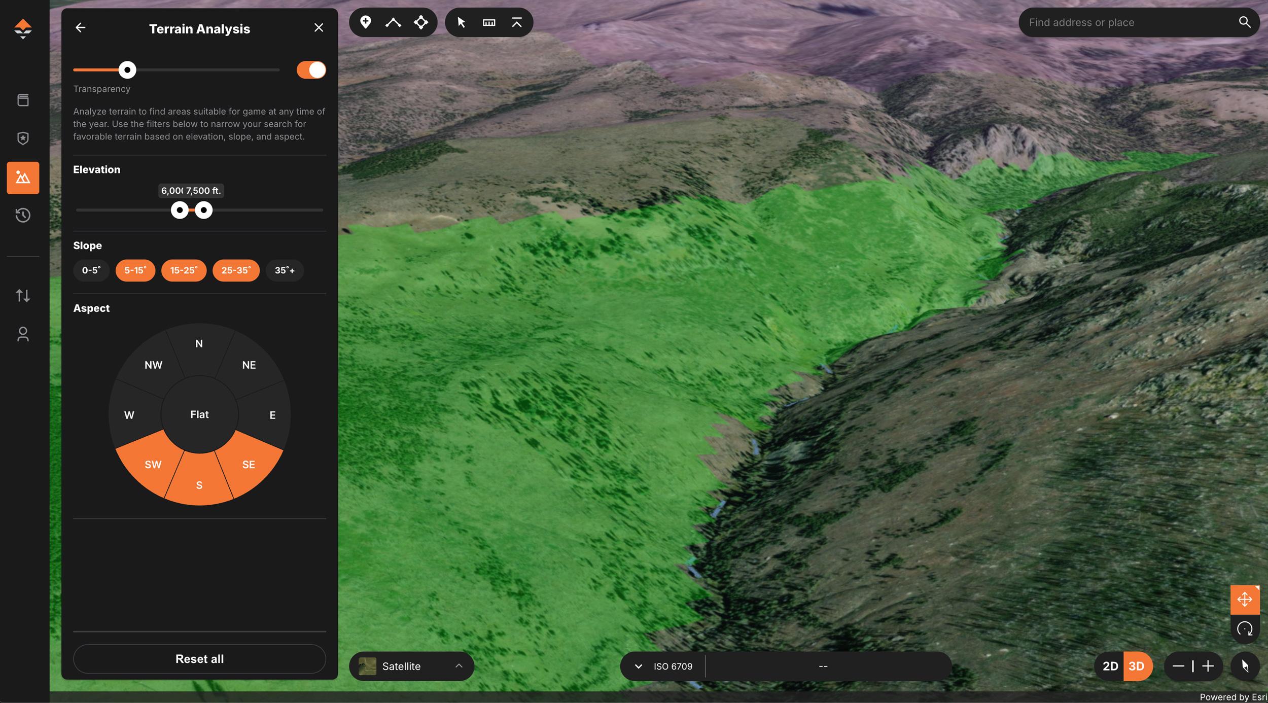
Using the GOHUNT Terrain Analysis Tool to help highlight spring bear spots.
Spring bear season in the western Lower 48 is a favorite hunt for many hunters. As the winter lull ends, the days lengthen, and the mountains come alive with vegetation and new life, the Black Bear emerges from their den, hungry and ready to forage. This can become the most successful time of year for hunting bears, as they often ignore their nocturnal and reclusive tendencies and choose to replenish their calories in the wide open south-facing slopes, where new vegetation is prevalent. While several states offer a spring bear season, I'll focus on my favorites: Arizona, Wyoming, Oregon, Idaho, and Montana, due to the accessibility. Here's a breakdown to help you choose your next spring bear hunting spot using the research tools found on GOHUNT and utilizing GOHUNT Maps to the fullest to find bears.
Most spring bear hunting in the lower 48 takes place during the relatively same time of year from March to June, depending on each state. Some states offer over-the-counter tags, and some offer drawn tags, each with benefits.
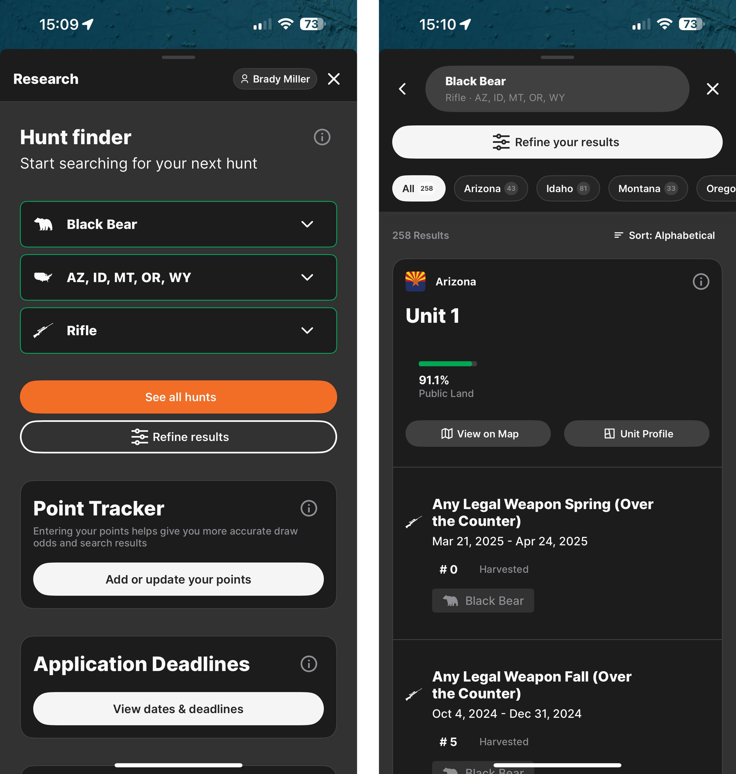
To start the search, a hunter can use the GOHUNT mobile app and select any species. In this case, we will select Black Bear. They can then choose the state if they know what states they have in mind (for this example, we will select Arizona, Idaho, Montana, Oregon, and Wyoming). Or you could select all states. And lastly, select a weapon choice.
The app will show the user what states and units have spring bear hunting for the selected time of year.
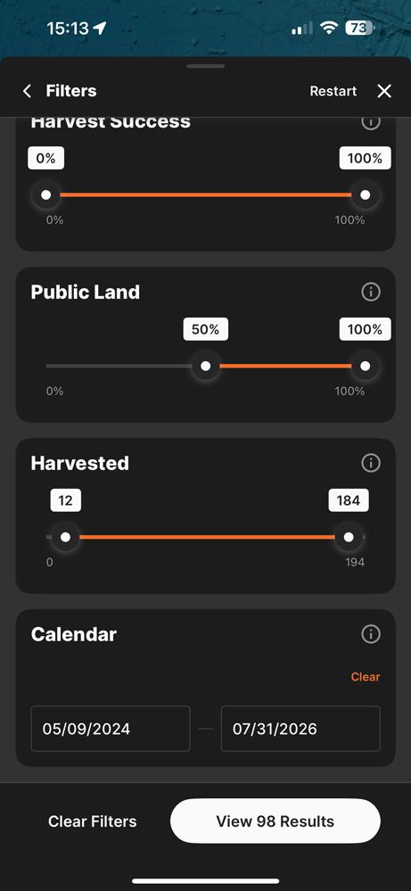
You can then can then jump up to "Refine your results" section and adjust public land percentages and harvest statistics, specifically the number of bears harvested, to see the units that may offer better hunting odds.
To avoid the most hunter interaction, I typically avoid areas with the highest harvest success (which correlates to the most hunters) in the state while looking for units with double-digit harvest numbers. I also pay close attention to unit size, as the data can be deceptive for large units or small units alike. Once I determine a state and unit, it is time to plan out when to go hunting to work out the rest of the logistics.
You can also narrow down the search for a bear hunt by season dates by when you want to hunt or, alternatively, isolate the springtime months that work best for your style of hunting.
Once you've chosen a state and unit, you must determine when to go hunting during a hunting season that can last over two months in some states. To help determine this, a hunter must understand basic black bear behavior. Bears enter torpor when winter weather arrives and food becomes scarce. They emerge when the weather improves and food sources, specifically plant life, become available. The first few weeks, after they emerge, are ideal for harvesting a mature bear, as they'll be actively feeding on plants and newly budded forbs late into the morning and a few hours before dark. After a few weeks, a bear will transition to nocturnal movements and become more challenging to locate.
Bears emerge from their dens at different times of spring in different states and even at different times in the same unit, depending on elevation. Some emerge in early March in portions of warmer states, such as Arizona, while others remain denned until May in northern states, like Idaho. This is weather, snowpack, and ultimately food-dependent, making spring bear hunt planning more complex than fall elk or deer hunts, where behavior is more consistent. Despite the complexity, I am positive that a hunter can find bears at any time of the spring, if they understand bear behavior and use tools to help them know where to look.
When scouting or hunting, a hunter should focus on southern-facing open hillsides near dense forests. Personally, I have found that bear hunting is at its best just below the elevation of the snowline, where food is more concentrated and the forest hasn't yet greened up. This is extremely hard to plan before arriving in a location and can change year to year, so the best way to determine this is to be onsite.
Alternatively, you can access snow layers on Mark Livesay's Treeline Academy Google Earth Pro Toolkit Bundle, which includes a spring bear data layer as a bonus.
Typically, my first hunt involves driving mountain roads and determining the snowline, especially on southern-facing slopes. If I observe snow or a lack of green vegetation on southern, open slopes, starting at 7,000 feet, I use my GOHUNT Maps Terrain Analysis Tool to highlight south or southwest-facing slopes with a 15 to 35-degree slope at an elevation of 6,000 to 7,500 feet. This shows "honey holes" where bears may find food while other areas are still snow-covered, lacking enough food. This Terrain Analysis Tool is an excellent asset for bear hunting, allowing me to isolate exactly what I am looking for and increase success.
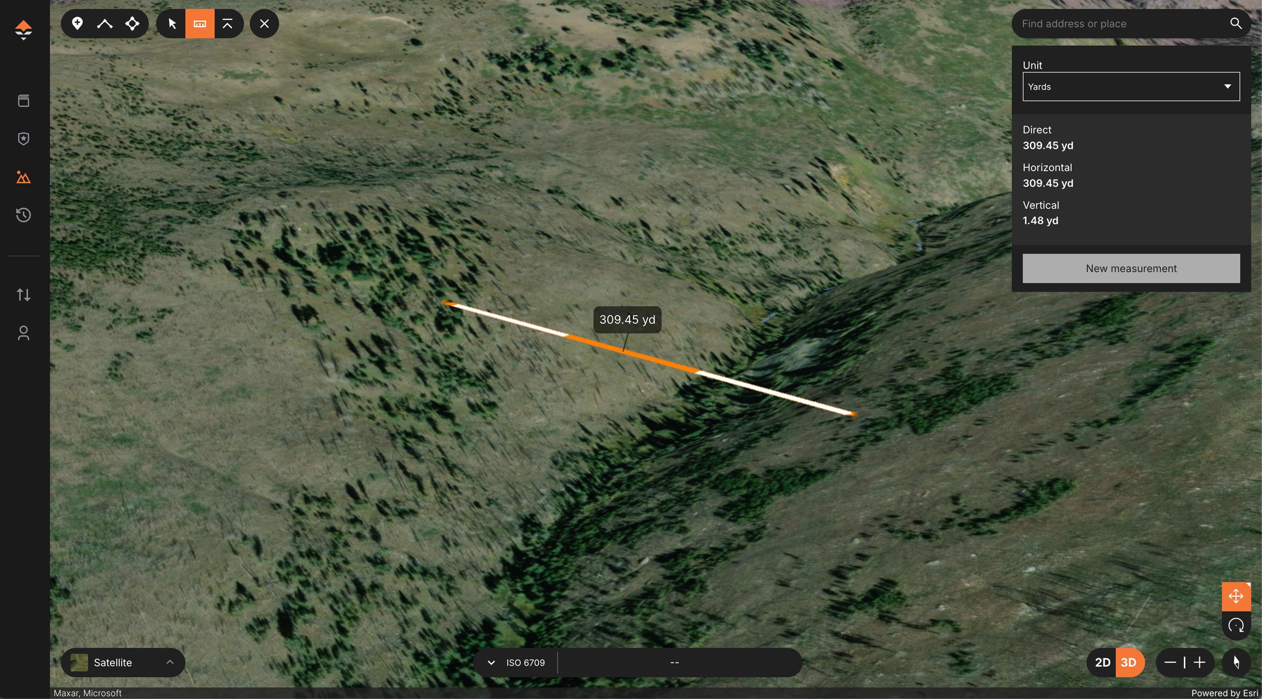
Once you find a promising location using GOHUNT Maps, you must find a shooting position that suits your skill set. I use satellite imagery to locate areas without trees adjacent to the areas that I believe bears will be on. Then, I use the measuring tool to determine if the location is close enough for a cross-canyon shot, which is my ideal situation, or if the only option is to be on the same side of the hill as the potential bear. The measuring tool shows the actual and adjusted shooting distance, preventing me from hiking to a great glassing point only to find it's out of shooting range. The 3D tool provides a rough estimate of what you might see from a given location and is a great way to understand the spot before your arrival fully.
No matter how much a hunter e-scouts and has a foolproof plan, we have yet to have a bear hunt that goes exactly as planned. The snow line may be higher or lower than expected, a road may be impassable, and the bears may not be where they were last year for various reasons. I typically start with multiple plans at multiple elevations during my e-scouting and use GOHUNT tools to help adjust once I'm on the ground. This has increased my success over the years and made choosing states, locations, and potential shooting positions more scientific and with less guesswork. GOHUNT's Filtering will help a hunter pick a state and unit and GOHUNT Maps will help a hunter e-scout and plan, and then, using the Terrain Analysis Tool, in combination with other tools, will allow a hunter to increase their success at finding bears.