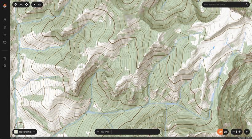


We have some very exciting news here at GOHUNT; our badass custom topographical map is now also available in the GOHUNT app! We’ve had our topographical map available on our desktop maps for a while, and we’re excited to bring it to the mobile app. You’ll be able to use our new topo map in 3D and 2D!
This topo map was designed based on the needs of hunters. This isn’t a standard topo map from decades ago, this is truly a better topo map experience.
We put a lot of time and effort into creating a topographical map that hunters need and will greatly benefit from during e-scouting and while hunting in the field. Also, this topo map gives you a very clean view that is easy to see details on. Our goal was to remove all the noise and give you added details when hunting.
You’ll instantly notice every detail of your hunt area with this topo map. We have incorporated custom hill shading in the map. This custom shading helps to easily see the relief and details of mountainous areas, providing you a hyper-detailed map of the ground floor.
When using topo in the field, you’ll easily be able to see trails, water sources, saddles, pinch points, places to glass, and much more at a higher level of detail. Everything you need to gain an edge when trying to identify animal movement.
You will also notice different contour line styling, designed to easily see contour index and contour interval lines. This is beneficial when planning a route through some tricky terrain.
At the end of the day, a topographical map is critical when e-scouting and on a hunt. If you want to learn more about how to read a topographical map, check out this article here.
We set out to build the best topographical map for hunters while at the same time making it clean and easy to see important details. Check out our topographical map today on the web version of GOHUNT Maps and on our mobile app.
What if a hunter built a topographical map? Well… now you get to experience the benefit yourself!