

At this point in the year, many hunters are soon heading out for an elk hunt. Personally, I have a few elk tags this year, and my mind has been firmly rooted in the September mountains for some time now. With my tags secured, most of my thought process has switched from “what tags can I draw?” to “what adventures can I now have?.”
In my current stage of life, I travel to hunt... a lot! Boots on the ground scouting trips are always valuable but are not always viable. For me, e-scouting has become hugely important, and with some practice and some intuitive mapping tools, I’ve found that I can be very effective in locating prime hunting areas prior to stepping foot in an area.
GOHUNT’s web and mobile mapping app is key to that success! If you’re not a current Insider member, now is the best time to join to get access to the best maps for hunters.
Note: All Insiders already have access to everything GOHUNT Maps (web, mobile app), plus they have access to all of the research tools like Filtering 2.0, Draw Odds, and application strategy articles.
In my opinion, people tend to overthink the thought process of an elk far more than they need to, both in the field and while e-scouting. Elk are generally fairly simple creatures in terms of what they need to survive and the conditions they’ll seek out. Knowing some of these ahead of time can really cut down on your search efforts.
First off, one of the biggest things to begin searching out in your quest for elk will be north-facing slopes. North-facing slopes embody everything that elk will be seeking out during the early archery seasons- Food, water, and cover. That is not to say that elk will only be found on north-facing slopes, but a lot of their day-to-day activity will be centered around them. On these north slopes, you will encounter bedding areas, wallows, water sources, travel routes, rutting areas, etc. Bottom line, I’ve always followed the mantra of starting at north slopes and then branching out from there.
Dark timber areas are generally going to be found on north-facing aspects and will be the primary bedding areas for most elk. These areas will provide great cover, all-day shade, and secure travel routes. You can find elk bedding and living in all types of vegetation types, but generally speaking, if an area has a few pockets of timber, the elk will seek these out.
This one is pretty obvious but food is a vital part of an elk's day and good feeding areas must be present in the location. Elk feed will vary greatly from climate conditions to your given location in the world but good feed will generally be found on north, east, and western slopes, although it can certainly be found on southern slopes as well. While looking over satellite imagery, I like to look for greener vegetation areas in close proximity to areas where I expect the elk to bed.
As with food, water is another obvious basic necessity of elk, but one that is very important. Elk need to water every day and locating areas with good water supplies can be a great starting point. In most mountain ranges, you can generally count on water being found in most deeper drainages, but steeper terrain can certainly pool most of the water into lower elevation areas. If the conditions are good, elk can travel some insane distances to get to water and hunters need to be aware of this. Water doesn’t need to be immediate but it needs to be feasibly reachable.
This is my favorite factor to consider as human pressure is an ever-evolving aspect and one that is fun to try to figure out. At their core, elk do not tolerate human presence well. So much so, that if a herd gets spooked badly, they may simply just vacate the area entirely and not look back. Elk try to avoid people as much as they can and considering that factor over most everything else will put you on elk faster in my experience.In general, I feel that most hunters tend to over-hype the areas where they are expecting to see elk and, consequently, end up overlooking the areas where the elk actually are. Everyone wants to kill a bull in a high mountain meadow as he’s screaming his head off, but the unfortunate truth is that more elk likely get killed in ‘ugly’ areas than they do the pretty ones. Before anyone goes there, I am using the term ‘ugly’ loosely as a way to describe down-fall ridden and near-vertical slopes.My favorite type of elk spot to look for are the ones that are closer to roads and feature a horrible hike in. One thing to consider here, you don’t need to hunt the backcountry to find unpressured elk.Typically, when it comes to avoiding humans and finding elk I like to look at spots pretty simply: If the spot has everything an elk needs - food, water, cover, and security - and it looks like the hike in is going to be brutal, then it’s probably worth checking out.
Once it’s time to start e-scouting, I like to first take a few minutes to get my map prepped. With this, I’m going to set up the basic layers and tools I’ll need to quickly identify elk spots.
This is a fairly basic list of layers and tools, but is just enough that I can quickly identify areas of elk habitat in a given unit.
During my initial run through an area, I am only concerned with dropping waypoints on any areas that get me excited. I look at these areas very broadly and will not do much in terms of investigating an area, yet. Essentially I am looking at three primary things:
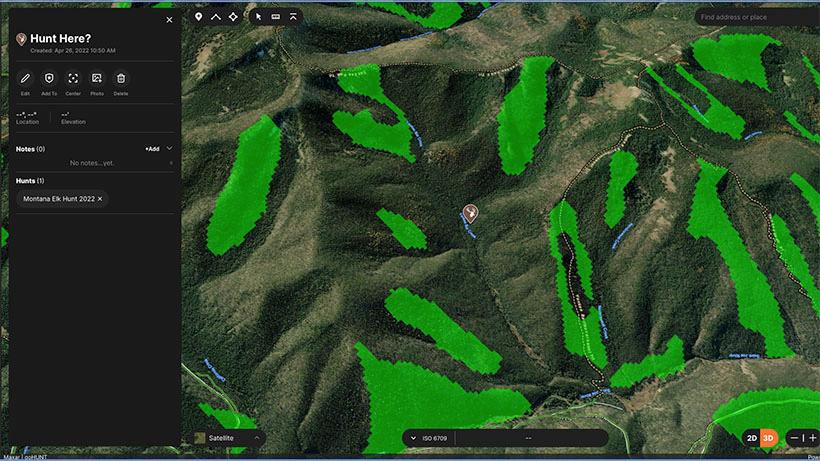
An example of a broad search in a unit landing me in a likely spot. The area that I’ve marked here has ample north-facing slopes, loads of timber, some open slopes, and very few access options for most hunters. This will be an area I can likely get away from others with minimal effort...if the elk are in here. Notice the Terrain Analysis tool highlighting all of the north slopes in green.
Another thing to consider is the elevation that you are looking at. The exact elevation elk will be found at will vary from state to state and unit to unit. As a general rule of thumb, I like to start with the highest elevations where timber is found and then I’ll move out from there.
Once I’ve gone through and identified some initial areas to consider I will then start deep diving into these individually. While doing so, I am going to be looking at a number of things but the first thing I want to do is confirm my suspicions and double-check my main priorities for an elk spot:
If I can check these boxes then I will start looking into more of the specifics. First off, I’ll add some new layers to my map to help with any additional e-scouting:
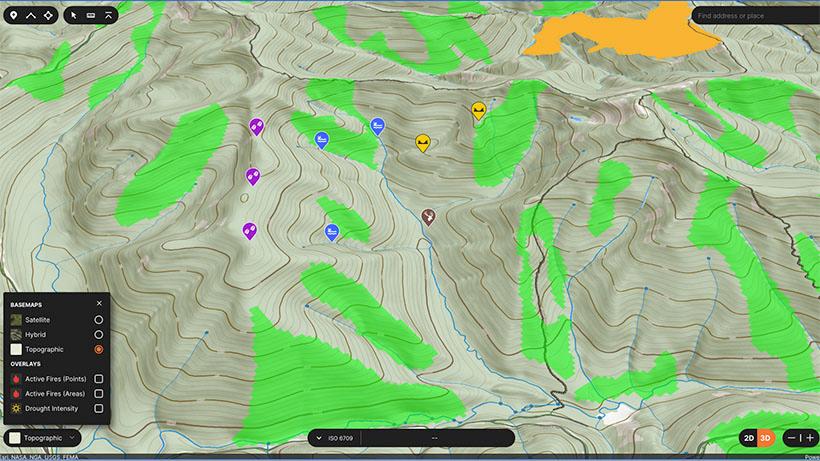
In the above screenshot, I have a few likely areas marked, including potential wallows, bedding areas, and saddles.
Now I’ll start going through the area and marking any areas that I feel could have some reliable elk activity. This could include saddles, potential wallows areas, benches and more. Marking these locations will do a few things for me - one, I now have some great spots to check if I do end up hunting in this area, and two, this will build confidence for me in gauging whether I want to spend time here or not.
When it comes to planning for a hunt, I always try to have as many potential spots marked on my map as possible. Even when backpack hunting, I like to have several spots picked out. You never know when things may change and the area you had planned to hunt has gone to hell. With your hunt plan, trust your gut. If there is any area that is just screaming to you, then hit that first and move from there. With elk, my preferred tactics above all else, is to just cover ground. Elk move a lot, and I like to do the same. For most archery elk hunts, I’ll be happy once I have 8-12 solid spots marked out on my map.
Transparency with the example map
Because I know someone will ask, this above example map was taken from a random state in an area I have never hunted, and I do not have plans to hunt, for now anyways. Would this area be included in my own personal hunt plan? Yes, absolutely! This area holds some great potential and just jumps out as a nice little overlooked spot. I like the collection of north slopes, the amount of terrain in this basin, and the general shape of this area. A simple loop from the truck could cover this main basin very effectively. This would be something I’d devote a morning or full day, but nothing more unless I was getting into elk.
Satellite base map - I’m a huge topo map guy, but during my initial search, I’ll use the satellite imagery base map as this will allow me to quickly identify timbered from open areas.
Private Land
Government Land - At times, I will turn this layer off as I find the colors tend to just distract me from what I am actually wanting to see on screen. I will generally verify that I am looking at public land and then turn this off.
Hunt Units
Roads and Trails
Terrain Analysis tool - The terrain analysis tool allows me to quickly highlight slopes based on what direction they are facing, this is excellent for identifying North facing aspects. Additionally, the Terrain Analysis tool also allows me to further filter slopes out by slope degree of angle as well as elevation range. Learn more here.
South Up - Lastly, one thing that really helps me visualize things is to spin my map so I am facing south as opposed to the typical north-up orientation. I find that this makes finding elk spots that much faster.
Does this area have north-facing timbered slopes?
Is this area remote or difficult to reach?
Overall, what is my gut saying?
Does this area have north-facing timbered slopes?
Is this area remote or difficult to reach?
Overall, what is my gut saying?
Water - This will highlight potential streams, springs, rivers, and guzzlers. This can be great for not only identifying potential drinking areas, but also wallows and areas where I myself might get water during the course of the hunt.
Wildfires - The wildlife layer goes hand in hand with elk and should be on the radar for anyone looking to hunt elk. Typically, when fire moves through an area it will deposit nutrients into the soil and any new growth will be highly sought after by most ungulates, but especially elk. There is a lot that goes into how long a burn area can be productive but typically those in the 1-6 year range will be worth a look. I don’t exclusively hunt burns but when they are present in an area I want to hunt, I definitely take notice.
Topo base map - The last thing I like to do at this point is to switch my map over to the topographic map. With the topo map, I can quickly identify ridge lines, benches, travel routes, saddles, and more.