Drawing a tag is only step one. Now the real work begins to figure out where to hunt in Montana with a general season or permit tag, plus how to approach e-scouting and tools you can use now to increase success this fall


How to view all of the Montana general season elk hunt districts on GOHUNT's Filtering research tool.
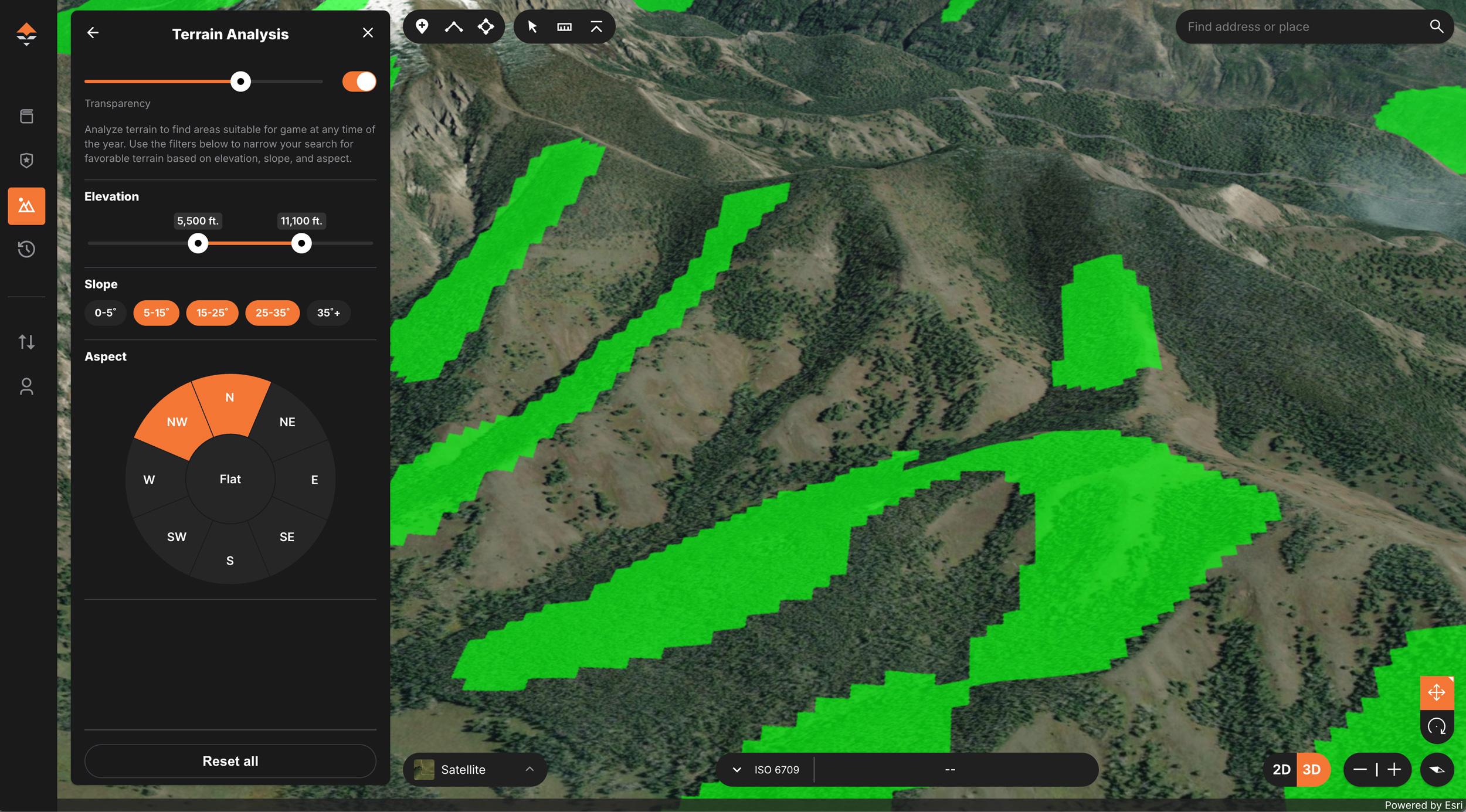
The Terrain Analysis Tool on GOHUNT Maps
Drawing a coveted elk or deer tag in Montana is a thrilling moment. Whether it's your first time or you're a seasoned hunter finally cashing in points, that successful draw is just the beginning. If you drew a tag this year, now the real work begins: research, planning, and preparation. And that’s where GOHUNT Insider shines.
With your Montana general season tag in hand, you’re now faced with big questions: Where exactly should I hunt? What does the terrain look like? How can I increase my odds of success this fall?
This guide breaks down everything you can do inside GOHUNT’s Insider research platform to make the most of your tag, from narrowing down units to reading maps like a pro.
Montana has massive general-season hunt districts scattered across the state, as well as more complex limited-entry districts. After you draw, it's time to get surgical with your location choices. This is especially important because with a Montana general tag (Big Game Combination, Elk Combination, or Deer Combination), you can hunt a plethora of areas. So you need to narrow down your selection to start developing a plan.
I say it a lot, but you really need to develop a plan and start this plan early!
For example, there are currently 123 general season elk hunt districts in Montana. And there's the same number (123) of general season mule deer hunt districts.
Bonus Tip: Use the "select seasons" and "weapon" filters to align with your exact tag type.
The beauty of this system is that you can research on the web side with a computer or use the GOHUNT mobile app.
Mule deer
If you're thinking of hunting Montana for mule deer, the article linked above is basically a giant data story and is a must-read to help you narrow down where to hunt! Access region-by-region breakdowns that take a look at harvest, residency, and much, much more.
Elk
The Montana General Season Elk: Narrowing Down Your Choices article walks through how to dissect Montana’s general elk season options using Insider tools. It emphasizes harvest statistics, terrain variation, and e-scouting tips that help you eliminate areas that won’t work for your hunting style.
Once you've identified a few promising hunt districts on Filtering, it's time to hit the GOHUNT Maps platform. This tool is integrated directly into Insider on both the web and our mobile app and allows you to:
Expert Strategy: Save 2-3 different "Plan A, B, and C" plans to account for access issues or hunting pressure.
The article "How to Narrow Down Where to Hunt When You Draw a Multi-Unit Permit" focuses on breaking down large, complex permit zones into manageable options. This information is essential when your tag allows you to hunt multiple units. It shows how to overlay map data and use terrain features to find likely elk or deer concentrations. This same information can be used for a general season tag when you have the option to hunt a bunch of units, like Montana’s general deer and elk tags.
Elk and deer aren’t truly evenly spread across the landscape, meaning they spend different times of the year occupying certain habitats. Understanding topography is key to finding where they feed, bed, and move.
GOHUNT Maps includes our proprietary custom detailed topographical map, but it takes some know-how to interpret it. And understanding how to read a topographical map is key, and then combine that with our Terrain Analysis Tool… and you’re setting yourself up for success.
The How to read a topographic map to find more elk this hunting season article is a goldmine for learning to read topographical maps effectively. It breaks down slope angles, access considerations, and how animals use terrain throughout the day. Perfect for anyone planning a backcountry or mobile-style hunt.
For every hunt district in Montana, we have what we call a Unit Profile that includes:
Combine this with Filtering and GOHUNT Maps to get the full picture before committing boots to the ground on your hunt or scouting trip.
GOHUNT doesn’t just help you choose a unit—it helps you prepare for it.
The GOHUNT Gear Shop is also fully integrated, with curated kits built for elk and deer hunters.
Drawing a general-season Montana deer or elk tag, or even a limited-entry permit tag, is often the culmination of years of waiting, building points, or beating the odds. But simply having a tag in your pocket doesn’t guarantee success. Montana’s vast landscapes, diverse terrain, and varying access issues make it one of the most rewarding yet challenging places to hunt. This is why being fully prepared is critical.
Everything outlined in this article—from our Filtering and Unit Profiles, to GOHUNT Maps and our Terrain Analysis Tool—translates directly into better decision-making in the field. Here's why it matters:
Montana is big, wild, and full of opportunity. GOHUNT Insider empowers you to make informed choices, maximize your time in the field, and ultimately walk away with meat in the freezer or antlers for the wall.
Drawing a tag in Montana is a huge win—don’t leave your hunt to chance. GOHUNT Insider gives you the edge at every step:
From research to maps to gear, everything is built to help you make that tag count.
This article was originally published on April 15, 2025, and has been updated.
Filter potential hunt districts by number of animals harvested, bull-to-cow ratios, public land percentage, and more: Target areas with solid animal numbers and good access. The data makes it easy to focus your efforts where they count.
Dive into Unit Profiles of prospective hunt districts: Avoid broad generalizations by looking at the specific areas where hunters surveyed (pressure) is lighter, or where the terrain and vegetation suit your hunting style. This helps you find honey holes that many hunters overlook.
View 3D terrain and satellite imagery: See ridges, valleys, and elevation changes to evaluate glassing spots, travel routes, potential bedding areas, and find areas elk and deer might live in.
Start an initial marking of waypoints for camp, glassing knobs, and access points: Build your hunt plan visually. Save key locations so you know how to hunt the unit and locate backup spots if things change.
Layer public/private boundaries, land ownership, trails, burns, and more: Ensuring you’re hunting legally and efficiently is always essential. Understanding access points and wildfire history can be game-changing.
Sync everything to your phone for offline use: The GOHUNT Maps app lets you take all of your e-scouting into the field, even without cell service, once you download layers for offline use.
Stack layers to zero in on areas with high opportunity AND access: One of my favorites is stacking layers like elevation, species distribution, and terrain type, which allows you to pinpoint the best overlap of animal presence and huntability.
View Montana Block Management maps: During the summer months (Typically around August 15), Montana FWP provides maps of all of the Block Management Areas in each region. You can also view these areas starting in the late summer on GOHUNT Maps.
Spot north-facing bedding slopes: These slopes stay cooler in the summer and are often used by elk and deer for mid-day bedding.
Identify benches, saddles, and migration funnels: These features are natural travel corridors and staging areas. Recognizing them helps you set up smarter ambush locations.
Full hunt unit breakdown: From terrain photos in the unit, vegetation breakdown, historical temperatures, and moon phases, all the way weapon/season insights.
Access notes and terrain overviews: Be informed about access, roadless areas, or extreme terrain. These sections can be helpful learning about the unit and how to approach your e-scouting.
Tag quotas and draw odds: Know what the chances are that you’ll draw for any of the species in this unit and how many tags are given out to residents and nonresidents.
Historical harvest success rates: Gauge how past hunters have fared by viewing the Animals Harvested graph, and set realistic expectations for your hunt. Also, you can check out the Hunters Surveyed graph to see how popular some general season Hunt Districts are.
Trophy potential and season trends: Understand the quality of animals available and how conditions have changed over the years.
Comments from other users: Each Unit Profile includes a comment section at the bottom where GOHUNT members can interact with one another. Our comment section is on an individual unit basis and is much more valuable than a random internet search and misleading information that you typically find on hunting forums. We have all seen how those discussions go on an open forum... Plus, users can share photos from the unit. Learn more about our Unit Profile commenting feature.
Customize gear lists for different terrain or weather scenarios: Build your gear list for your specific hunt based on whether you’ll be backpacking into alpine country or truck camping near lowland meadows.
Read gear reviews from serious western hunters: Get real insights on boots, optics, shelters, and layering systems that work in Montana’s rugged environments. Check out those gear-based articles here.
Watch videos on e-scouting, gear reviews, tag strategies, and much more: Learn about everything from shooting your bow, tuning your bow, dialing in your rifle, optic choices, e-scouting, and navigating each state’s draw system on our GOHUNT YouTube channel.
You’ll waste less time: Instead of blindly exploring unfamiliar terrain, you’ll know where to focus your efforts based on data-backed insights.
You’ll hunt smarter, not harder: Understanding where animals move, bed, and feed helps you intercept them more efficiently. You’ll be in the right place at the right time.
You’ll increase your odds of success: The combination of scouting, knowledge of pressure zones, and tailored gear can be the difference between a filled tag and a story of what could’ve been.
You’ll have confidence in your plan: Having A/B/C hunt plans mapped and researched ahead of time gives you the flexibility to adapt on the fly if conditions change or pressure spikes.
Target the best terrain: Use GOHUNT Maps and Unit Profiles to find where animals might be and develop a plan of attack.
Avoid the hunting pressure: E-scout potential places where access and pressure are more favorable.
Maximize your time afield: Have a game plan dialed in and backup options before the season even starts.