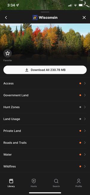


Example of what you'll now see across all states.
The GOHUNT team has been busy lately curating and assuring quality in 500 new map layers! This further expands the data coverage in the midwest, southern, and eastern states.
We know map layers are critical for helping you plan and execute hunts by knowing where you can navigate and informing your plan with land usages such as fires, timber cuts, water, and wildfire. We are excited to extend our layer coverage across all states!
You can download and try GOHUNT Maps risk-free for 7-days:
Example of what you'll now see across all states.
As always, these layers are available in both the web version of GOHUNT Maps and in our mobile app.
Note: be sure to keep your mobile app updated to receive all of our fresh enhancements. Plus, if you've previously downloaded a state layer on the mobile app, be sure to keep those layers up to date as well.
If you have any questions or feedback, please reach us at feedback@GOHUNT.com or drop a comment below.
Need a walk-through on importing your waypoints to GOHUNT Maps? We have you covered! Learn more at the link below:
Forest Service Motorized Roads and Trails
Trails
Historic Wildfires 2010-2021
Timber Cuts
Grazing Allotments
Springs
NEW Public Access content for Wisconsin, Michigan, Texas, and Minnesota
The addition of 1.1 million acres of public access in California
Updated Public Access for Oregon
New Mexico Private Land
New Mexico Government Land
Oregon Hunter Access Programs
California CDFW Owned and Operated Lands
Wisconsin Forest Tax Law Points
Wisconsin DNR Managed Properties
Michigan Commercial Forest Lands
Michigan Hunter Access Programs
Texas Wildlife Management Areas
Minnesota Walk-in Access Sites
Minnesota DNR Managed Lands
Wyoming Deer Regions